Release 1.19 of the Model My Watershed web application was made public today!

Release 1.19 introduces a user interface overhaul to improve workflow and embedded help, and paves the way for the many new features we have planned for the next year. CLICK TO EXPAND.
We are looking forward to responses to our overhauled user interface, which we designed to substantially guide a user through the workflow to Select, Analyze and Model their area of interest, while also paving the way for all the new features we plan to roll out in the next year with our latest funding from the William Penn Foundation.
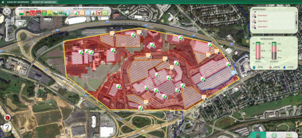
We’ve done this with a new landing page that introduces the user to the MMW web app and the workflow and a new Select Area page with short explanations of all the methods and help button tooltip popups that provide additional explanations and links to our new Technical Documentation. In fact, we’ve embedded help tooltips throughout the app (enjoy finding them all!). We added information to help the user select between our Site Storm Model and our Watershed Multi-Year Model, and we’ve updated Model page with dropdown scenario interface instead of tabs, to create space for better scenario management and upcoming new features.
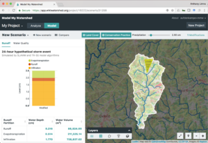
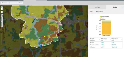
Our new Model Page improve scenario management and paves the way for future enhancements simulating conservation practices. CLICK TO EXPAND.
We’ve also added a pile of additional new features, including:
- A new Layer selector, to better guide the user toward exploring all the cool data behind MMW.
- Ability to upload a custom Area of Interest polygon, either as a shapefile or GeoJSON.
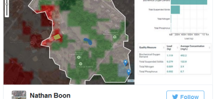
- Ability to download any table to open in any spreadsheet application, such as Excel or Google Sheets.
- Ability to search by name for any USGS Hydrological Unit (HUC)
- There are many more small new features. Can you find them?
With Release 1.19, we’re also introducing the first of many “under the hood” improvements to MMW performance. The most noticeable will be that we’re caching, or storing, results from well known Areas of Interest, such as HUCs, counties, etc. The first time a user runs a specific predefined area of interest, it will take the usual time for all the results to get calculated. However, all future selection of that area, by any user, will show results in only a second or two, because we’re now just fetching the results from the first run, rather than calculating them all over again. This also paves the way for future performance enhancements and new features. Stay tuned!
For a full list of all improvements, see our Release Notes at https://github.com/WikiWatershed/model-my-watershed/releases.