Release 1.20 of the Model My Watershed web application was made public today!
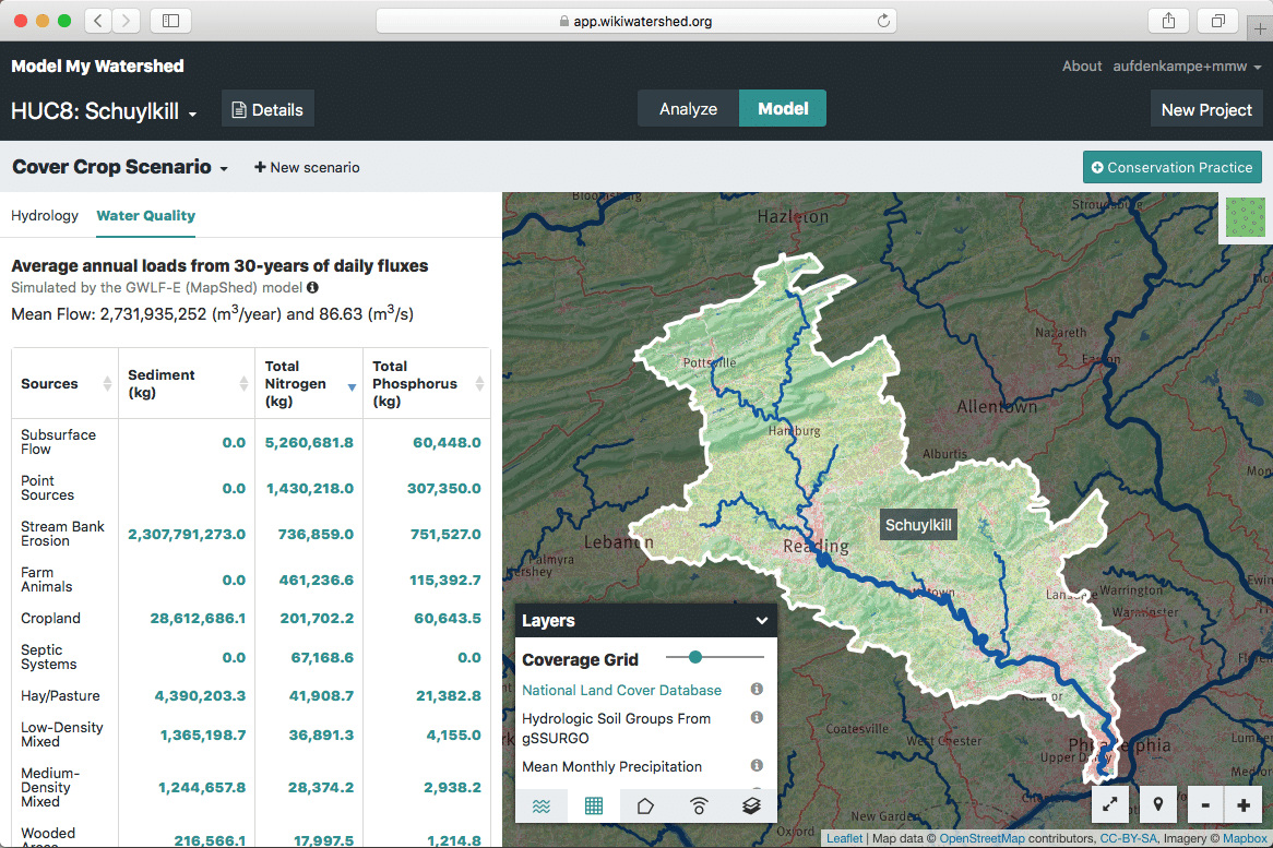
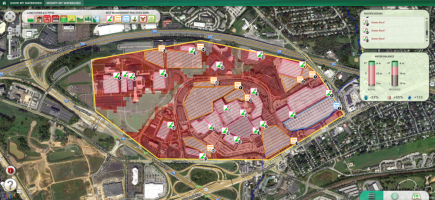
MMW Release 1.20 unveils substantial performance improvements, which allows rapid simulation much larger areas, such as the HUC8 Schuylkill River (4,958 km2). CLICK TO EXPAND.
We are excited for users to immediately benefit from the very significant performance improvements that we’re releasing today. While Release 1.19 focused on an overhauling the user interface to make room for new features, Release 1.20 unveils nearly half a year of hard work overhauling the machinery “under the hood” to provide the high performance we need for the features that we’ll roll out in the next year with funding from William Penn Foundation.
These performance enhancements will be noticeable. Analysis will be two to ten times as fast. Areas of Interest less than 600 square kilometers, such as HUC10 & HUC12 units, will analyze in just a few seconds, and a large HUC8 (~5000 km2) that might have taken 20+ seconds to analyze will now complete in ~8 seconds. We have also considerably sped up both models. For GWLF-E/Mapshed model runs, a baseline 15 second speed improvement was introduced, with additional reductions in running time based on the size of the area. This was achieved while also adding additional geoprocessing to more accurately model several soil variables instead of using hard coded or look up values. On average, a GWLF-E/Mapshed model run is about 20s faster after the recent changes for a HUC10. We’re not experiencing any timeouts.

MMW Release 1.20 also introduces a new Compare view for simulations of different scenarios in the Site Storm Model.
In addition to these massive “first time” performance improvements, all analysis and model results are cached for any named area. After someone analyzes an area once, results will return in about 1 second, for anyone, regardless of size. Both models also take advantage of caching results now, so that subsequent runs (including adding BMPs) can gain additional improvements. For example, on a fresh HUC10, it may take about 8-10 seconds to run the Current Conditions scenario for Multi-Year. Adding a BMP to that project will only take ~3 seconds to apply and recompute.
In Release 1.20 we also added a few features and fixed many bugs. Most prominent of our new features is our complete redesign of the Compare view interface for the Site Storm Model.
For a full list of all improvements, see our Release Notes at https://github.com/WikiWatershed/model-my-watershed/releases.