WikiWatershed, the online toolkit featuring a watershed-modeling web app developed by Stroud Water Research Center and partners, has new features to help individuals learn about and protect their watersheds.
The toolkit was recently awarded the 2017 Governor’s Award for Environmental Excellence by the Pennsylvania Department of Environmental Protection. Awardees of 16 different projects that represent the very best in innovation, collaboration, and public service in environmental stewardship were recognized at an event hosted by DEP and the Pennsylvania Environmental Council on April 25 at the Hilton in downtown Harrisburg.
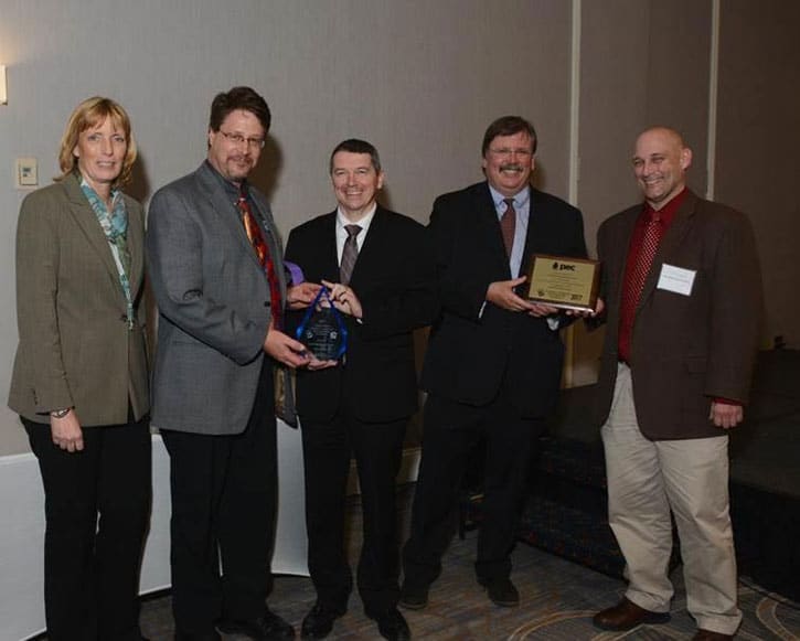
During the 2017 Governor’s Award for Environmental Excellence event on April 25 at the Harrisburg Hilton, the Stroud Center received a plaque presented by the Pennsylvania Environmental Council, and an award presented by the Pennsylvania Department of Environmental Protection (DEP). From left: PA Department of Conservation and Natural Resources Secretary Cindy Adams Dunn, Stroud Center Executive Director David Arscott, DEP Secretary Patrick McDonnell, Pennsylvania Environmental Council President and CEO Davitt Woodwell, and Stroud Center Director of Watershed Restoration Matt Ehrhart. Photo courtesy of PEC.
Stroud Water Research Center, known around the world for its cutting-edge freshwater science, education, and watershed restoration activities, developed WikiWatershed with team members from Azavea (now Element 84), the University of Washington Applied Physics Laboratory, the Concord Consortium, Meliora Design, Utah State University, the Academy of Natural Sciences of Drexel University, and Millersville University.
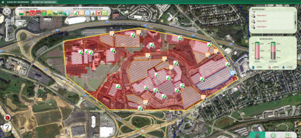
WikiWatershed is intended for users to share watershed-model scenarios, watershed-monitoring data, and watershed-management stories as an open, collaborative community. For example, among the available tools, the Model My Watershed app features an intuitive, user-friendly interface that makes advanced watershed modeling easy from a web browser.
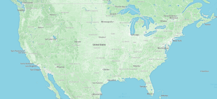
Anyone can harness the supercomputing power of the Amazon cloud to visualize and analyze national datasets of land cover, hydrologic soil types, stream networks, and watershed boundaries to predict stormwater runoff and water quality for any area of interest in the continental United States.
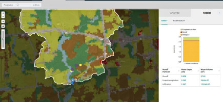
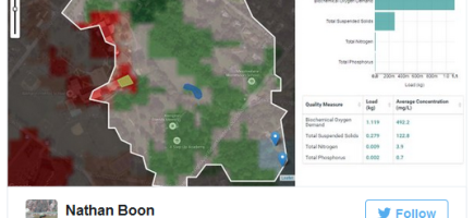
Additional data newly available for visualization and analysis within the Delaware River Basin includes stream network overlays, Stream Reach Assessment Tool overlays, point sources of permitted pollution discharges, county-based animal data, USGS stream monitoring data, and more. Users can analyze data and create scenarios in a 24-hour storm event model and a multiyear model for any area of interest in the lower 48 United States.
The latest version of Model My Watershed uses professional-grade models to enable citizens, conservation practitioners, and municipal decision-makers to compare how different conservation or development scenarios for their neighborhoods and their watersheds could modify runoff and water quality.
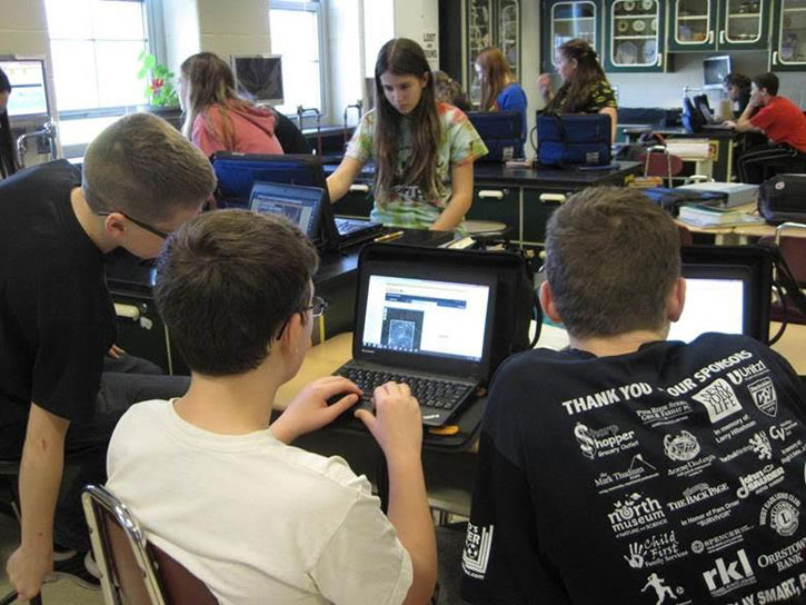
Model My Watershed was also designed for students and teachers to learn systems thinking and geospatial analysis skills in the context of place-based problem-solving for watershed science. The NSF Division of Research on Learning has funded a collaborative project between the Stroud Center, Millersville University, and the Concord Consortium for further development of the app and teaching environmental sustainability (awards DRL-1418133, DRL-1417527, and DRL-1417722). About 75 teachers in California, Iowa, Kansas, Virginia, and Pennsylvania piloted a watershed curriculum last school year, and more teachers are currently piloting a revised curriculum this school year.
“During the teacher trainings last summer, teachers were excited to explore Model My Watershed features and began to customize the model curriculum for their students,” says Director of Education Steve Kerlin, Ph.D. “After implementing the use of Model My Watershed in their classes, teachers have reported that the experience of using real data to solve real problems has been highly impactful.”
The latest version of Model My Watershed was jointly funded by the William Penn Foundation and the National Science Foundation. It expands capabilities that were prototyped in 2010-2011 with NSF funding to a national scale, and it adds enhanced capabilities, such as rapid watershed delineation available nationally and high-resolution data layers available for the Delaware River Basin.
“A user can select an area anywhere in the continental United States and quickly and easily see how freshwater resources will improve or deteriorate if you plant a forest or add a building,” says Anthony Aufdenkampe, Ph.D., a senior environmental scientist at LimnoTech, who specializes in making scientific data and models easily accessible to the public. He is a co-principal investigator for the Model My Watershed project. “Model My Watershed is the first national-scale tool in the WikiWatershed toolkit. Our vision is for WikiWatershed users to share watershed-model scenarios, watershed-monitoring data, and watershed-management stories as an open, collaborative community.”
“The beauty of this app is its accessibility. Almost anyone can start using it and easily learn how to do watershed modeling,” says Melinda Daniels, Ph.D., head of the Fluvial Geomorphology Group and also a co-principal investigator on the project. “The level of analysis embedded in the app would normally take someone many hours of coursework to learn how to do; now it can be applied quickly by schoolchildren, citizens, municipal decision-makers, and conservation practitioners with little, if any, instruction.”
And the results are super fast. There’s no need to track down a land area’s soil data and then use complex equations to calculate how a new development or restoration project will affect local water quality. With a few mouse clicks, the Model My Watershed app reveals an estimate of the impact in a flash.
“The William Penn Foundation is committed to supporting work in the Delaware River watershed that helps ensure an adequate supply of clean water for future generations,” said Andrew Johnson, William Penn Foundation’s program director of watershed protection. “This pivotal project will vastly improve the ability of municipal decision-makers and conservation practitioners to accelerate and amplify their conservation impact in the Delaware River watershed.”
WikiWatershed and Model My Watershed were funded in part by:
- National Science Foundation (grants DRL-1418133, DRL-1417527, DRL-1417722, DRL-0929763, and DRL1433761)
- William Penn Foundation (grants 103-14 and 12-17)
- Stroud Water Research Center
- Virginia Wellington Cabot Foundation
- The Dansko Foundation
- Generous donations from Peter Kjellerup and Mandy Cabot
Donations large and small help the Stroud Center provide WikiWatershed to the public for free. Tax-deductible donations can be made at www.wikiwatershed.org/donate.
About Stroud Water Research Center
Stroud Water Research Center seeks to advance knowledge and stewardship of freshwater systems through global research, education, and restoration and to help businesses, landowners, policymakers, and individuals make informed decisions that affect water quality and availability around the world. Stroud Water Research Center is an independent, 501(c)(3) not-for-profit organization.
About The William Penn Foundation
The William Penn Foundation, founded in 1945 by Otto and Phoebe Haas, is dedicated to improving the quality of life in the Greater Philadelphia region through efforts that increase educational opportunities for children from low-income families, foster creativity that enhances civic life, and ensure a sustainable environment.
WPF’s environmental work funds efforts that help accelerate conservation of the Delaware River watershed. In an unprecedented collaboration to protect and restore water quality, more than 50 leading nonprofits have joined together in eight targeted areas where, informed by science, they are aligning priorities for restoration and land protection. Known as the Delaware River Watershed Initiative, it aims to amplify conservation impact which can be corroborated by periodic water quality assessments. Go to DRWI.net for more details.
About the National Science Foundation
The National Science Foundation (NSF) is an independent federal agency that supports fundamental research and education across all fields of science and engineering. In fiscal year (FY) 2016, its budget is $7.5 billion. NSF funds reach all 50 states through grants to nearly 2,000 colleges, universities and other institutions. Each year, NSF receives more than 48,000 competitive proposals for funding and makes about 12,000 new funding awards. NSF also awards about $626 million in professional and service contracts yearly.