
Last updated on 2022-12-01
Please note: Model My Watershed’s Watershed Multi-Year Model is now the primary framework for running the latest GWLF-E model version. It has replaced MapShed and BASINS because those desktop applications were built on the aging MapWindow GIS package that is no longer supported. If you have questions beyond what is provided in this documentation, please contact us so that we can connect you with MapShed developer Barry Evans, Ph.D.
Alternatively, you can run the latest version in Model My Watershed.
*Note: data downloads are in the form of zip files on Google Drive. If your firewall prevents access to Google Drive, please email webmaster@stroudcenter.org for assistance. Disk space required numbers do not include image files created by MapWindow.
5.1 MapShed Demo Data
- Download MapShed demo data from Google Drive
Contains sample data for learning and testing purposes. Download size: 1.65 MB | Disk space required: 3.85 MB | Version number: 1.2.1 | Date last modified: June 17, 2014
5.2 Pennsylvania Data
You must download the statewide data and the data for your region.
5.2.1 Pennsylvania Statewide Data
- Download Pennsylvania statewide data from Google Drive
Contains GIS layers and weather files for the entire state of Pennsylvania. Download size: 135 MB | Disk space required: 191 MB | Version number: 1.2.1 | Last modified: June 17, 2014
5.2.2 Pennsylvania Region-Specific Data
Contains streams and raster data sets for each region.
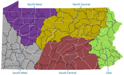
- Download Eastern Pennsylvania data from Google Drive
Download size: 29.7 MB | Disk space required: 168 MB | Version number: 1.3 | Last modified: December 6, 2014 - Download North Central Pennsylvania data from Google Drive
Download size: 55.8 MB | Disk space required: 106 MB | Version number: 1.3 | Last modified: December 6, 2014 - Download Northwest Pennsylvania data from Google Drive
Download size: 37.7 MB | Disk space required: 74 MB | Version number: 1.3 | Last modified: December 6, 2014 - Download South Central Pennsylvania data from Google Drive
Download size: 56 MB | Disk space required: 220 MB | Version number: 1.3 | Last modified: December 6, 2014 - Download Southwest Pennsylvania data from Google Drive
Download size: 36.1 MB | Disk space required: 74.3 MB | Version number: 1.3 | Last modified: December 6, 2014
5.3 New York and New England
You must download the regional data and the data for your specific section.
5.3.1 Regional Data
- Download the New York/New England regional data from Google Drive
Contains GIS layers and weather files for the entire New York/New England region. Download size: 68.6 MB | Disk space required: 100 MB | Version number: 1.2.0 | Last modified: October 22, 2013
5.3.2 Section Data
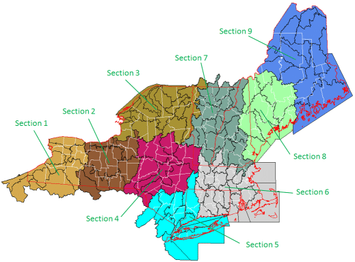
Contains streams and raster data sets for each section.
- Download New York/New England Section 1 data from Google Drive
Download size: 131 MB | Disk space required: 889 MB | Version number: 1.1.0 | Last modified: July 23, 2012 - Download New York and New England Section 2 data from Google Drive
Download size: 164 MB | Disk space required: 773 MB | Version number: 1.1.0 | Last modified: July 23, 2012 - Download New York and New England Section 3 data from Google Drive
Download size: 193 MB | Disk space required: 1.05 GB | Version number: 1.1.0 | Last modified: July 23, 2012 - Download New York and New England Section 4 data from Google Drive
Download size: 194 MB | Disk space required: 962 MB | Version number: 1.1.0 | Last modified: July 23, 2012 - Download New York and New England Section 5 data from Google Drive
Download size: 133 MB | Disk space required: 1.24 GB | Version number: 1.1.0 | Last modified: July 23, 2012 - Download New York and New England Section 6 data from Google Drive
Download size: 171 MB | Disk space required: 1.33 GB | Version number: 1.2.0 | Last modified: February 4, 2016 - Download New York and New England Section 7 data from Google Drive
Download size: 242 MB | Disk space required: 1.27 GB | Version number: 1.1.0 | Last modified: July 23, 2012 - Download New York and New England Section 8 data from Google Drive
Download size: 179 MB | Disk space required: 970 MB | Version number: 1.1.0 | Last modified: July 23, 2012 - Download New York and New England Section 9 data from Google Drive
Download size: 233 MB | Disk space required: 1.93 GB | Version number: 1.1.0 | Last modified: July 23, 2012
