Release 1.24 of the Model My Watershed web application was made public on Tuesday, 18 December, 2018! This release has several significant new data layers, features, and performance and graphical updates. We are thrilled to finally have these enhancements available for all to utilize. The following is an abbreviated list of changes and updates; additional details can be found in our Technical Documentation.
New Data Layers to Visualize
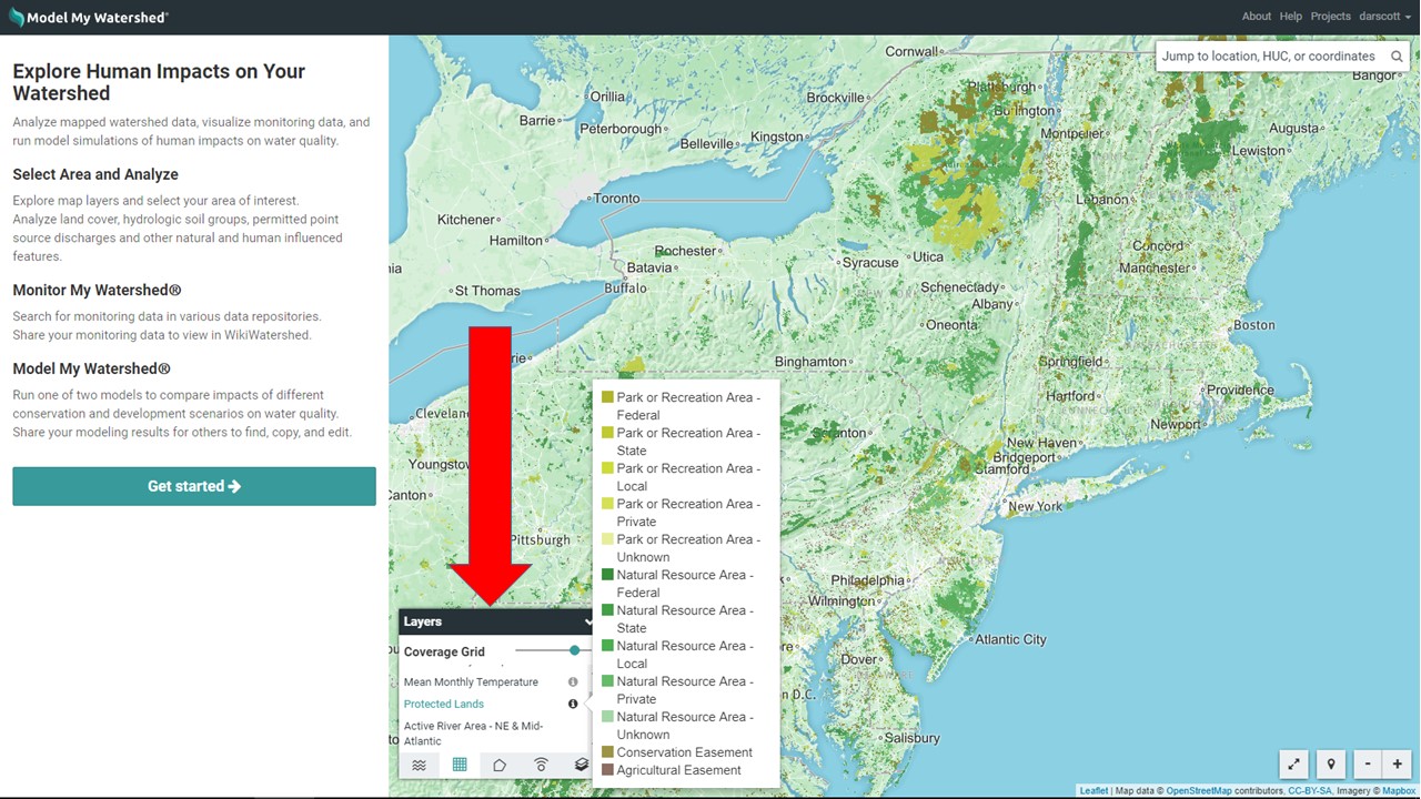
Several new datasets have been added to the “Layers” table under “Coverage Grid” that can be visualized by clicking on the layer (and legend keys can viewed by clicking on the “!” information symbol. Briefly, these layers are (for more information click here):
- Protected Lands: The Protected Areas Database of the United States (PADUS) is the official inventory of public parks and other protected open space assembled and published by the U.S. Geological Survey Gap Analysis Program in 2016.
- Active River Area: The “Active River Area” data layer was developed to provide a conservation framework for assessment, protection, management, and restoration of freshwater and riparian ecosystems (Smith et al. 2008; PDF download).
- Delaware River Basin (DRB) Urban Land Future Forecasts: These DRB-specific data layers were created by Dr. C. Jantz et al. at the Center for Land Use and Sustainability at Shippensburg University. These layers, collectively called DRB2070 Versions 1 and 2, represent a revised baseline, a business as usual forecast, and alternative forecasts (“corridors” and “centers”) for changes (increases or decreases in extent) to “developed land use” in the Delaware River Basin, out to 2050.
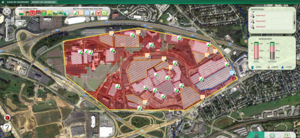
New “Monitor” Feature Includes WQP, a Multi-Catalog Free-Text Search for Monitoring Data
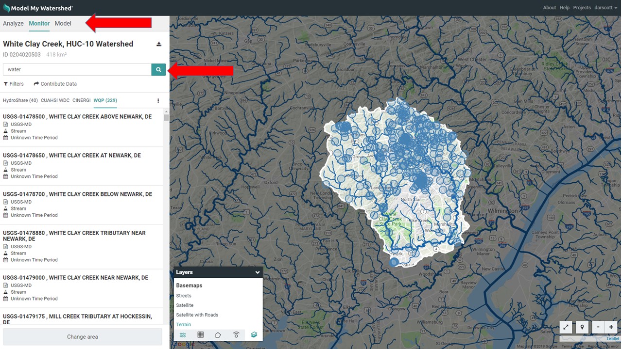
The “Monitor” feature within Model My Watershed (new in release 1.22 [March 2018]) allows any user to search multiple data catalogs/repositories for related datasets. After geospatial analysis of an Area of Interest, the user can search within that area for datasets contained in four separate data catalogs: HydroShare, CUAHSI WDC, CINERGI, and WQP (described here).
The Water Quality Portal (WQP) is a new catalog that we’ve added to this search. WQP is a cooperative service sponsored by the United States Geological Survey (USGS), the Environmental Protection Agency (EPA), and the National Water Quality Monitoring Council (NWQMC). It serves data collected by over 400 state, federal, tribal, and local agencies. Learn more about this data catalog on the Water Quality Portal.
The list of datasets found with any simple search can be filtered by free-text search and by time period coverage. A dataset can be selected for additional details, such as the dataset abstract and links to sources and web services. Once a user clicks on the word “Monitor,” a free-text search box is revealed on the left side panel. Typing a word or text string and clicking the “search” button will initiate the search.
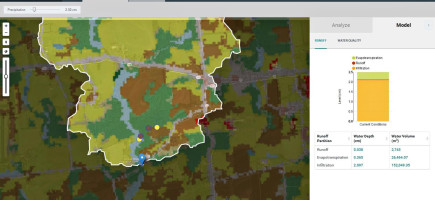
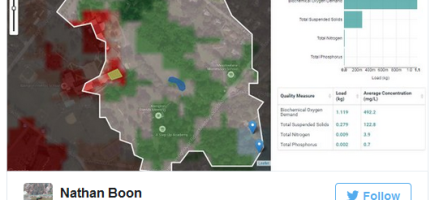
Major Improvements and New Features to the Watershed Multi-Year Model
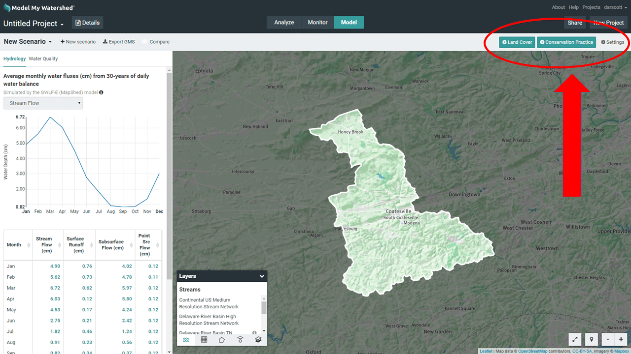
For starters, we’ve improved the performance (4x faster) of the GWLF-E algorithm that is the foundation for this model. We’ve also re-calibrated the Watershed Multi-Year Model and you can find a summary of those procedures and results here.
We’ve added the new options for changing your model under the “New Scenario” option that includes the following (see the technical document for details):
-
- The ability for the user to change/re-define land cover (however, you still must have the same total acreage with in project area after your change).
- Two more agricultural BMPs, “Conservation Tillage” and “Reduced Tillage” for rural areas;
- The ability to change model parameter settings for conservation practice efficiencies (e.g., cover crop or other BMP coefficients for nitrogen, phosphorus, and sediment); assumptions of loads from Wastewater Treatment Plants or septic systems; and livestock densities and grazing access.
- The ability to modify other model settings like the streambank erosion adjustment factor, the sediment delivery ratio, tile drainage assumptions, or groundwater N and P concentration assumptions.
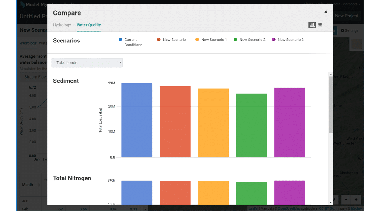
Lastly, we’ve added the “Compare” feature for the Watershed Multi-Year Model (similar to the “Compare” feature for the Site Storm Model), which allows the user to see model results in a side-by-side comparison for up to five “Scenarios.”
Units Conversion Option
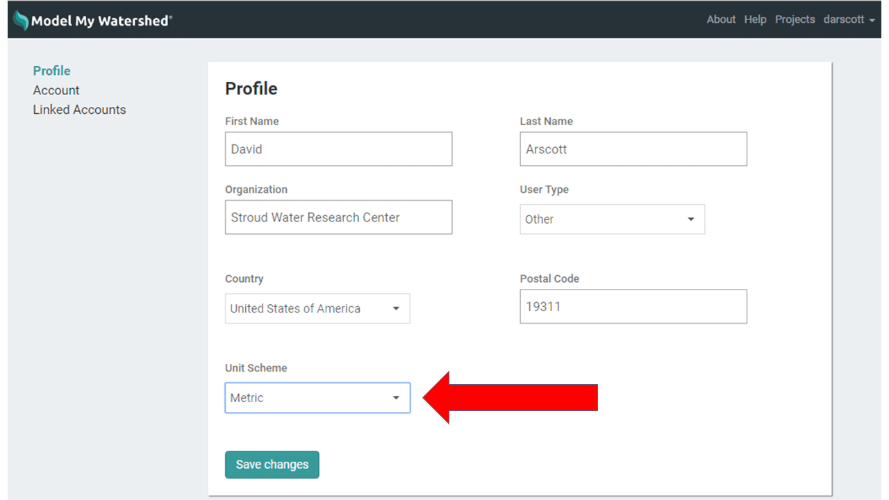
This feature has been long requested by our most regular users — we’ve finally added an option to switch units for any of your projects from metric to U.S. Customary units! To find this option,
- Click on your login name in the upper right hand corner of the black bar and click “My Account.”
- Click to the “Profile” screen and look for “Unit Scheme.”
- Click the drop-down menu and select either “Metric” or “US Customary” and then “Save changes.”
Now, if you re-open a project, your units will be converted to the new units option selected. Please note, that to propagate this change in any projects saved to HydroShare, you will need to export your project once again.
Design Updates and Other Changes to the User Interface
We’ve updated the Model My Watershed branding and URL to clearly show that, while the web app is part of the WikiWatershed toolkit, it resides on a separate website. The old app.wikiwatershed.org URLs still work but will redirect you to https://ModelMyWatershed.org.
We’ve also added and updated our “Terms of Use,” “Privacy Policy,” and “Cookie Policy,” which can be found on the “About” page or listed in your initial/new “User Account Request” page.